
Connecting Jericho Corners and Riverside
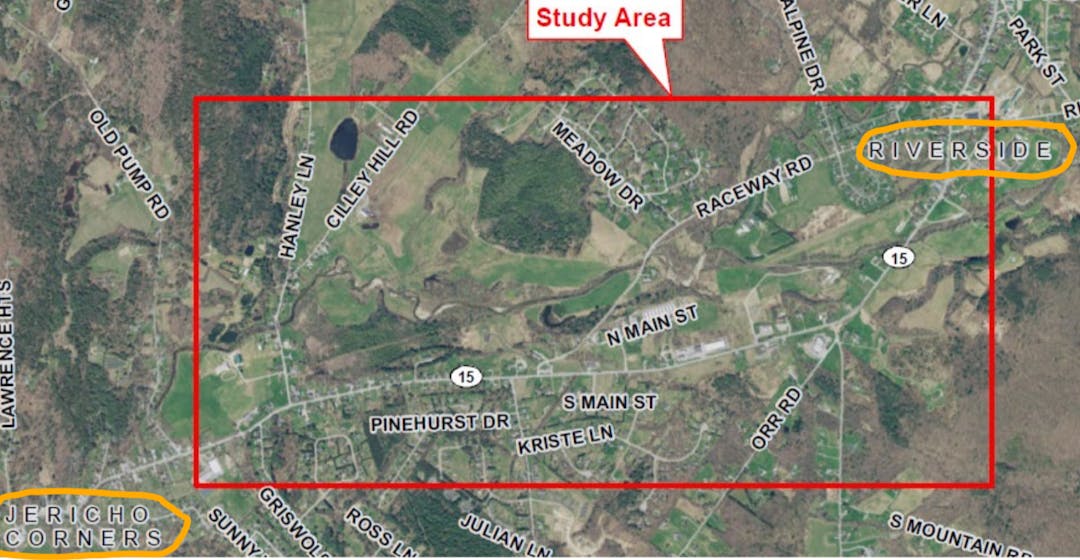
The Town of Jericho is working with the Chittenden County Regional Planning Commission (CCRPC) and their consultant, Stantec, to explore options for a multi-use path to connect Jericho Corners (Jericho Elementary School/Griswold Street) with Riverside/Flats (Browns River Middle School/Mills Riverside Park) and determine which is most feasible. One option is adjacent to the south side of Route 15 and another is following along an old railroad bed through private property behind the homes on the north side of route 15.
Read more below...
-
Selectboard Votes on Preferred Option
On April 4, 2024 the Selectboard voted to choose "Alternative 3" for the multimodal path (extending the walkway from Griswold to Packard, crossing the road and adding signage to Raceway), Next steps will be to finalize the report and then pursue grant funding for design and construction.

-
7/20/23 Alternatives Presentation Slides
-
Public Meeting Thursday July 20th at 6:30 PM

The Town of Jericho, along with the Chittenden County Regional Planning Commission (CCRPC) is working with Stantec engineers to conduct a scoping study to examine the feasibility, impacts, and costs associated with a new 5 to10-foot-wide shared use path to connect the Jericho Corners area to the Riverside Village/Underhill Flats area.
The goal of this study is to determine the best route to connect the two parts of the Town with a safe path for walking and biking. One of the alternatives being investigated is a path along the southern side of VT Route 15. The path would be separated from the roadway with a 5-foot-wide grass strip, where possible, and would be a combination of a 5-feet-wide concrete sidewalk and 10-feet-wide path with an asphalt surface. The other alternative is a path that roughly follows an old railroad bed alongside the Browns River and onto Raceway Road. Please see the documents tab to the right for a look at the two alignments.
The desired outcome of this study is to establish a preferred alternative. If a preferred alternative is determined to be feasible, and has the support of the community and Selectboard, the path can become eligible for grant funding for detailed design and construction. If the path moves forward to detailed design, construction is likely 5-10 years away.
At this phase of the study, the project team is seeking input from potentially impacted property owners and residents. Please join us at the Selectboard meeting on July 20th at 6:30 pm at the Town Hall or via Zoom to voice your support, questions, and/or concerns regarding the project. At this meeting, the two alternatives will be compared, potential impacts will be discussed, costs will be shown, and the next steps will be described.
This is a follow up to the first public meeting about the project that was held on February 21st at the Jericho Planning Commission meeting.
-
Multi-modal Path Q and A
 Why are we doing this scoping study?
The Planning Commission continues to hear that Jericho residents want more infrastructure that provides safe ways to walk and bike more around town - to get to school, visit friends, shop and dine. Fewer car trips improves health and well-being, and reducing emissions is better for clean air and water.
The backbone of a safe and useful bike/ped network would be a connection between our three Village Centers. This was identified as a priority in a Bike & Pedestrian Master Plan for Jericho that was developed in 2015. (click to view study report)
The current study will look at 2 options to connect Jericho Corners (Jericho Elementary School/Griswold Street) with Riverside/Flats (Browns River Middle School/Mills Riverside Park) and determine which is most feasible. One option is along the south side of Route 15 and the other is following along an old railroad bed through private property north of route 15.
The Chittenden County Regional Planning Commission receives federal funds to work with consultants and towns to complete scoping studies like these. Jericho is fortunate to only pay a small portion of consulting fees for this work.
Didn't we already study this idea?
Yes. The Town hired Dubois & King (D&K) in 2016, to develop plans to connect Jericho Corners with Riverside. (click to view study report)
-
D&K considered 3 options for a sidewalk/path. One on the north side of Route 15, one on the south side of Route 15, and a "cross-country" path using the old railroad bed north of route 15, which runs parallel to Browns River, generally from Cilley Hill Road to Raceway Road/Route 15. The 2016 study considered:
Traffic
Who would use the path and where would they go (i.e. school, work)
Options for crossing Route 15
Impacts to homes and utilities along the route.
The river, wetlands, and private property issues (no existing right-of-way) were perceived as major obstacles to using the old railroad bed, therefore the option of using that route was not fully explored.
The option on the north side of route 15 had more significant impacts to utilities, required more property acquisition, required more residents to cross route 15 in order to access the path, and was more expensive than the south side option.
In 2016 public engagement was minimal - fewer than 10 residents attended the primary meeting and about 10 others wrote emails.
In May 2017, the Selectboard selected the option for a sidewalk/path along the south side of Route 15, separated by a green strip where possible as the preferred alternative.
Why repeat the study? Why aren't we just building something?
In 2017, D&K estimated costs to build a connection would range from $600,000 to $900,000. State and federal grants pay to design and build most sidewalks and paths. Towns typically cover 10%-20% of the costs; grants cover 80%-90%.
Jericho applied for Vermont Agency of Transportation (VTrans) grants to build segments of the Route 15 south side path but was declined twice. VTrans gave feedback on improvements needed to strengthen a grant application in order for the project to be funded. Without grants, building the connection would be too expensive.
Since the original study, residents continue to press for safe bike and pedestrian infrastructure with a lot of interest in a cross-country path option. The Planning Commission and the Selectboard decided to re-open the project and fully evaluate the cross-country railbed option along with the south side of Route 15 option.
The Planning Commission believes that more public engagement will lead to a better design with more public support, and a better design will lead to a stronger application which is more likely to win funding. In fact, we have already seen higher participation rates with over 70 people attending the initial public meeting in February, 2023.
-
Scoping Study Presentation Slides


Documents
-
 Jericho Path Supplemental Scoping Project Final Report.pdf (5.02 MB) (pdf)
-
Jericho Path Final Report Appendices.pdf (41.5 MB) (pdf)
-
Revised Alternatives Presentation 2024-02-15.pdf (14.8 MB) (pdf)
-
Bike & Ped Master Plan (with Appendix) - 2015 (13.5 MB) (pdf)
-
Jericho Route 15 Multi Use Path Scoping (Dubois & King) - 2017 (28.3 MB) (pdf)
-
Connecting Riverside and Jericho Corners - Alternatives Presentation (5.41 MB) (pdf)
